Renewable energy in the Playa Lakes Joint Venture (PLJV) region is a rapidly growing industry that will continue to expand in the coming years. As this happens, it is important to ensure that siting new energy infrastructure is done in ways that benefit both industry and wildlife.
Many of the same state-of-the-art maps and decision support tools that we use for biological planning can be adapted to help renewable energy developers site new projects that minimize impacts to birds and their habitats. In some cases, where the impact cannot be avoided, these planning tools can be used to design workable offsets and mitigation.
Energy Development Siting Recommendations for Playas
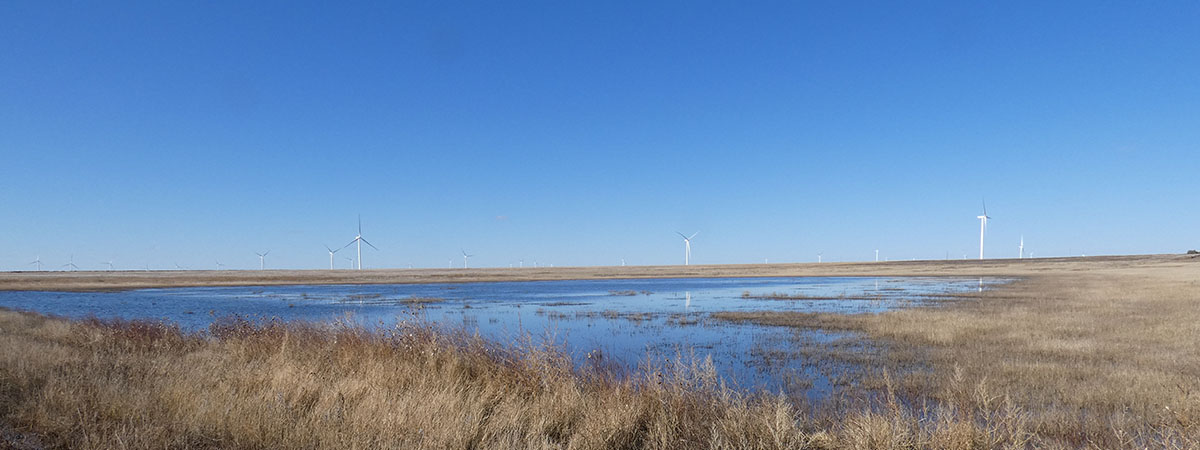
The PLJV region, which is home to many important renewable energy sites, is also densely populated with playas. Because they are temporary wetlands and often dry, playas can go unnoticed or be overlooked, presenting problems for developers once water and birds show up.
Unfortunately, the impact of energy infrastructure on these important wetlands, and the wildlife that depend on them, is not fully understood. Overall, we advise that all energy development and associated infrastructure avoid large isolated playas and playa clusters, as infrastructure on or near playas or playa clusters may adversely affect wildlife habitat and energy development on playas may limit their hydrologic function.
Playa clusters are mapped using waterfowl data to reflect how waterfowl use and travel between playas, representing areas where obstacles would be detrimental. Playa clusters were developed by modeling how waterfowl, specifically Northern Pintails, use playas. Birds tend to be attracted to clusters of playas and, once there, are likely to move among playas in a cluster. The resultant maps tend to map an avoidance distance of the cluster while clearly delineating the cluster of playas themselves.
While much of the focus has been on siting wind turbines, solar energy development will also be a key player in the region. There are few published studies evaluating the effects of solar developments on birds and other wildlife. Given the scarcity of publicly available information, we endorse a precautionary approach as best.
PLJV’s recommendations for energy development near playas are used by state wildlife agencies and shared with industry professionals to be considered during the siting process. View PLJV’s Energy Development Siting Recommendations for Playas >>


Clean Energy Voluntary Donations
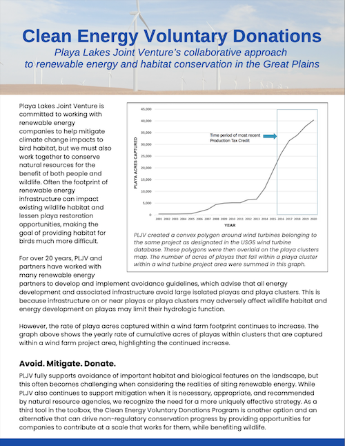 PLJV is committed to working with renewable energy companies to help mitigate climate change impacts to bird habitat, but we must also work together to conserve natural resources for the benefit of both people and wildlife. Often the footprint of renewable energy infrastructure can impact existing wildlife habitat and lessen playa restoration opportunities, making the goal of providing habitat for birds much more difficult.
For over 20 years, PLJV and partners have worked with many renewable energy partners to develop and implement avoidance guidelines, which advises that all energy development and associated infrastructure avoid large isolated playas and playa clusters. This is because infrastructure on or near playas or playa clusters may adversely affect wildlife habitat and energy development on playas may limit their hydrologic function.
However, the rate of playa acres captured within a wind farm footprint continues to increase.
PLJV fully supports avoidance of important habitat and biological features on the landscape, but this often becomes challenging when considering the realities of siting renewable energy. While PLJV also continues to support mitigation when it is necessary, appropriate, and recommended by natural resource agencies, we recognize the need for a more uniquely effective strategy. As a third tool in the toolbox, the Clean Energy Voluntary Donations Program is another option and an alternative that can drive non-regulatory conservation progress by providing opportunities for companies to contribute at a scale that works for them, while benefiting wildlife.
Interactive Playa Map and Dataset
Our playa map and downloadable playa data layers allow you to explore the playa region and investigate playas, wind farms, and other features of the landscape. You can sort data by criteria you specify, upload your own shapefile to view a boundary on the map, and print what you see on the screen.
This map helps users better understand how energy development and associated infrastructure can avoid playa clusters, based on the belief that infrastructure on or near playas or playa clusters may adversely affect wildlife habitat and energy development on playas may limit their hydrologic function. The tool also maps clusters (see information on clusters above).
Current map data include playas, playa clusters, and a suite of layers relevant to wind energy development, including current wind turbine locations based on FAA data. Users can click on individual playas to get more information on playa size, playa condition, and the playa’s wetness frequency over time.
Before you get started, watch a short tutorial video, which walks you through all the features and shows you how to use the tool. You can explore the embedded map below. To explore all the features, open the Playa Map in a new browser window.
You can download the probable playas dataset as a shapefile. The dataset is a regional compilation of several original data sources including the National Wetlands Inventory, Soil Survey Geographic database, and satellite imagery. These wetland data were analyzed for each state in the PLJV region — Colorado, Kansas, Nebraska, New Mexico, Oklahoma and Texas — to create the most comprehensive playa location map possible using remote sources. The playas layer contains locations of more than 70,000 playas across the PLJV region. For more information on how they were created, download the release notes, which include a detailed list of the data sources and methods used.
You can also download the playa clusters shapefile. Playa clusters represent groups of playas that likely provide increased benefits to wildlife as compared to playas that are more sparsely distributed. Research shows that clusters of playas are more frequently used by migrating waterfowl and shorebirds than sparsely distributed playas (Farmer and Parent 1996, Brennan 2006, Cariveau and Pavlacky 2008, Webb et al. 2010). Playa clusters were defined by identifying areas with either high playa density or high playa surface area, according to duck abundance data collected on playas.
We encourage user feedback and would like to hear stories of how you’re using playa data in your work, all of which will help us to continue adding and improving our playa tools. Please send us your comments.

Playa & Renewable Energy Collaborative
The Playa & Renewable Energy Collaborative aims to raise awareness of the importance of playas within the renewable energy industry while also facilitating conversations between wildlife and energy development professionals on how the groups can more effectively interact.
By collaborating, renewable energy developers and natural resource conservationists can ensure playas and renewable energy infrastructure continue to benefit both people and wildlife for years to come.
GET INVOLVED
To explore how PLJV’s tools and guidance can be a part of your planning process, contact Mike Carter or Anne Bartuszevige.